


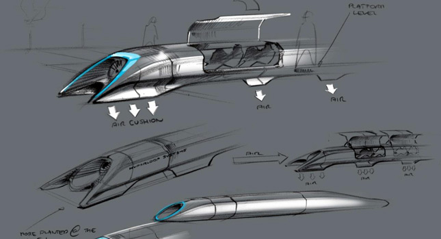
The idea launched by Tesla and SpaceX boss Elon Musk is creating a Hyperloop system that would be able to carry lots of people very quickly from point to point across the US, much in the same way conventional trains do – the difference would be the speed with which this would be achieved.
The first route originally envisioned was the one from San Francisco to Los Angeles, estimated to cost some six billion dollars to complete.
However, PopularScience has come up with a hypothetical map of what a complete North American Hyperloop network would look like, which cities it would link, and how much shorter commute times would be – they have an interactive map up, featuring comparative information between driving from one destination to another, taking the train there, or using this new third way.
Cost-wise, it would apparently be considerably cheaper to build and get running than it would a regular high-speed rail system, and this would also have the advantage of being built above ground, following highways and roads, so as not to require expropriations.
Still, the most important and beneficial aspect would be the shortening commute times; San Antonio to Mexico City in 75 minutes, New York to Montreal and San Francisco to LA in 35 minutes.
By Andrei Nedelea
PHOTO GALLERY
